California's natural parks go well beyond Yosemite — the state protects the world's tallest trees in Humboldt County, old-growth redwoods 12 miles from San Francisco at Muir Woods, tufa towers rising from a 70-square-mile salt lake east of the Sierra, and an island archipelago accessible by ferry from Ventura. McArthur-Burney Falls drops 129 feet year-round from a basalt cliff in Shasta County; Anza-Borrego Desert in San Diego County has bloom events that draw visitors from across the state in wet winters.
10 destinations selected from a curated US travel dataset — prioritized by regional distribution, visitor significance, and independent research. Must-see and Worth-the-detour ratings reflect relative value within California.
Jump to: Northern California Parks · Bay Area, Central & Southern Coast · Planning Notes
Northern California Parks
California's north stretches from the foggy Sonoma coast to Humboldt's redwood forests and the volcanic peaks of the Cascades. These parks require a car and a commitment to distance.
Redwood National and State Parks Must-see
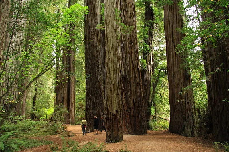
Humboldt County · Orick
Redwood National and State Parks protect the world's tallest living things — coast redwoods reaching up to 380 feet, with some specimens standing for over 2,000 years. The park complex covers 139,000 acres across Del Norte and Humboldt counties. The Tall Trees Grove trail (8 miles round trip from a gated trailhead) accesses verified record-holders; free permits are required from the Kuchel Visitor Center in Orick. Lady Bird Johnson Grove offers a 1.4-mile paved loop through old-growth without the permit requirement. Fern Canyon in Prairie Creek Redwoods State Park (accessible via a seasonal vehicle permit) has 50-foot fern-covered canyon walls used in Jurassic Park 2. Closest lodging is in Orick, 4 miles south of the Kuchel Visitor Center, or Crescent City, 40 miles north.
Watch on YouTube · View on Google Maps
Mount Shasta (Volcanic Peak & Spiritual Mountain) Must-see
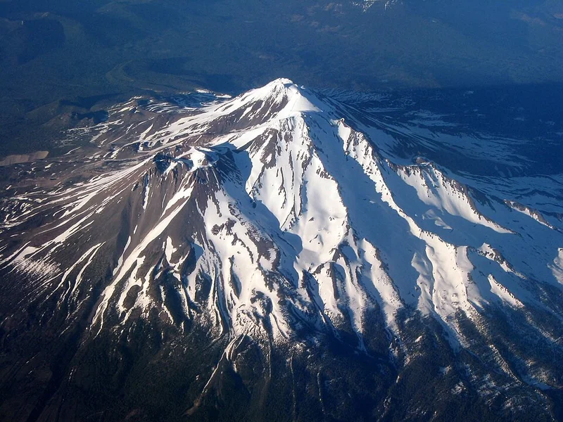
Siskiyou County · Mount Shasta
Mount Shasta rises 14,179 feet above Siskiyou County — the second-highest peak in the Cascade Range, with a topographic prominence of 9,822 feet (visible from over 100 miles away). Day hikers regularly reach the 10,000-foot Red Banks without mountaineering equipment on the Avalanche Gulch route; reaching the summit requires crampons, an ice axe, and a summit pass available at the Mount Shasta Ranger District office. The mountain holds five glaciers, including Whitney Glacier — the largest in California. The town of Mount Shasta at the base (elevation 3,600 feet) has hotels, gear shops, and a climbing outfitter community. Panther Meadows at 7,500 feet, a 2-mile accessible trail, is the most visited high-elevation area without technical climbing.
Watch on YouTube · View on Google Maps
McArthur-Burney Falls Memorial State Park Must-see
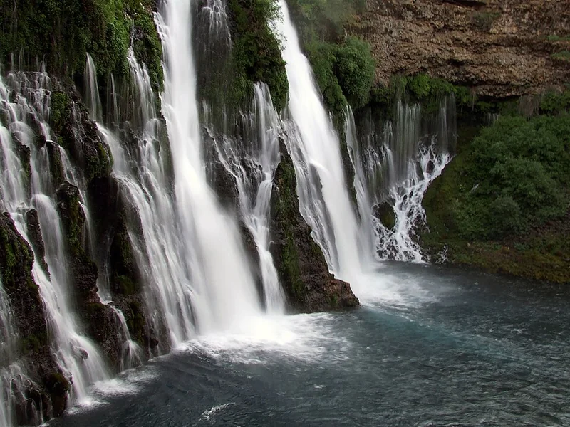
Shasta County · Burney
Burney Falls drops 129 feet year-round from a basalt cliff — fed by underground springs that discharge 100 million gallons of 48°F water per day regardless of seasonal rainfall. Theodore Roosevelt reportedly called it the Eighth Wonder of the World. The 1.3-mile Burney Falls Loop drops to the base of the falls and back; the Pacific Crest Trail also passes through the park on a 9.3-mile stretch to Lake Britton. A swim beach on Lake Britton operates May through October; boat rentals are available at the park's concession. Camping: 128 sites with reservations required June through August. Burney is 55 miles east of Redding on CA-299; the park is 6 miles northeast of Burney on CA-89.
Watch on YouTube · View on Google Maps
Salt Point State Park (Sonoma Coast) Must-see
Sonoma County · Cazadero
Salt Point State Park covers 6,000 acres of the Sonoma Coast — one of the few California parks with legal scuba diving access to an underwater preserve. The Gerstle Cove Marine Reserve, the first underwater reserve established in California, protects starfish, octopus, and abalone habitat accessible to divers from the beach. Horseback riding, hiking, and tide pool exploration are available across 20 miles of coastline; the Stump Beach Trail (1 mile) reaches a sheltered cove often calmer than the exposed headlands. Pygmy forest of stunted bishop pine and cypress grows on the park's eastern boundary — the result of a hard clay subsoil that limits tree growth to 6 feet. The park is 90 miles north of San Francisco on CA-1, 18 miles north of Jenner.
Watch on YouTube · View on Google Maps
USA Travel Planner — Google Sheets
One purchase. Every US state. Forever.
A pre-filled travel dashboard for every US state — we are actively building them out.
- 75+ curated attractions — pre-researched for you
- Built-in budget tracker (countdown, expenses, remaining)
- Step-by-step planning tabs
- Buy once — get all future states free as they launch
Bay Area, Central & Southern Coast
Point Reyes National Seashore Must-see
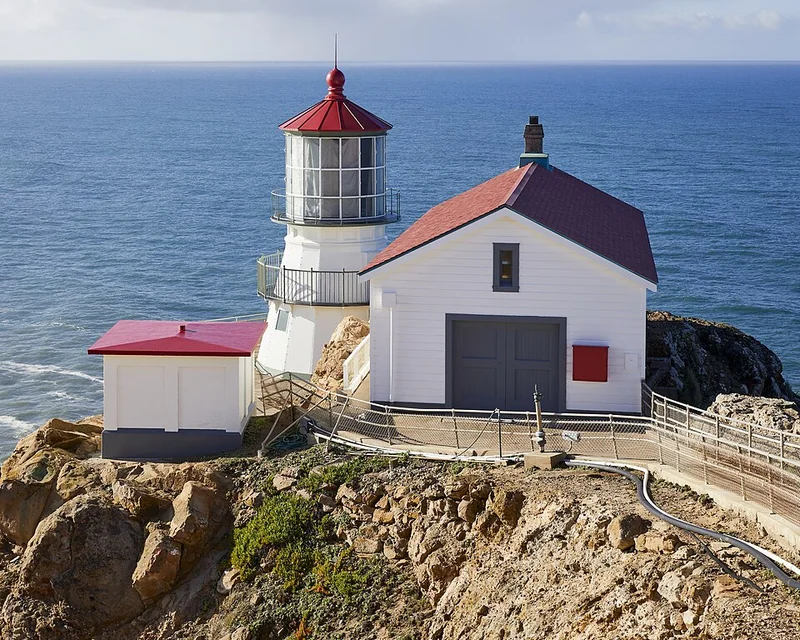
Marin County · Point Reyes Station
Point Reyes National Seashore covers 71,000 acres of coastal wilderness 30 miles northwest of San Francisco — geologically separate from the mainland on the Pacific Plate, meaning it has moved 35 miles northwest over the past 20 million years. The Point Reyes Lighthouse sits at the western tip of the peninsula, accessible via a 300-step staircase and open Thursday–Monday (10 a.m. to 4:30 p.m.); the headlands around it are the foggiest place on the US West Coast. Tule elk roam the Tomales Point Trail (9.4 miles round trip) through the 2,600-acre Tomales Point Tule Elk Reserve — the only free-ranging elk herd at Point Reyes. Drake's Beach offers sheltered swimming when the fog lifts. Four hike-in campgrounds require advance reservations through recreation.gov.
Watch on YouTube · View on Google Maps
Muir Woods National Monument Must-see
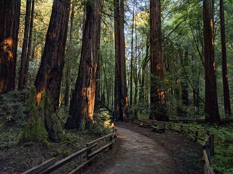
Marin County · Mill Valley
Muir Woods protects 558 acres of old-growth coast redwoods 12 miles north of San Francisco — the closest old-growth redwood forest to a major US city. Trees in Cathedral Grove reach 258 feet tall and 1,000 years old; the 1-mile Main Trail boardwalk runs through the heart of the grove. Timed entry parking reservations are required year-round at gomuirwoods.com; the shuttle from Sausalito Ferry Terminal or the Mill Valley Park & Ride avoids the narrow access road. The Dipsea Trail from Muir Woods to Stinson Beach (3.8 miles one-way, 1,400-foot elevation gain) is the route for the oldest trail race in the US. Admission required; under 15 is free.
Watch on YouTube · View on Google Maps
Channel Islands National Park Must-see
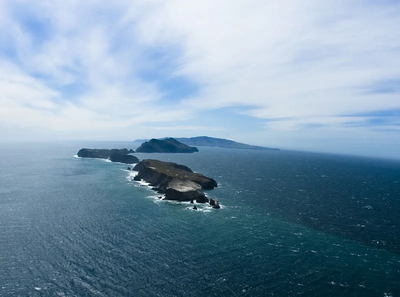
Ventura County · Ventura
Channel Islands National Park protects five islands off the Ventura coast — often called the Galapagos of North America for endemic species found nowhere else. Santa Cruz Island, the most visited, is 1 hour by ferry from Ventura Harbor via Island Packers. Painted Cave on the north shore of Santa Cruz is one of the world's largest sea caves — 1,227 feet deep and 100 feet wide at the entrance; kayak tours enter from the water. Snorkeling in the kelp forest around Scorpion Anchorage produces sea otters, leopard sharks, and bat rays. Camping on Santa Cruz requires a reservation through recreation.gov; ferries return the same day or the next if staying overnight. Whale watching along the ferry route adds grey whales (January–March) and blue whales (June–September).
Watch on YouTube · View on Google Maps
Anza-Borrego Desert State Park Must-see
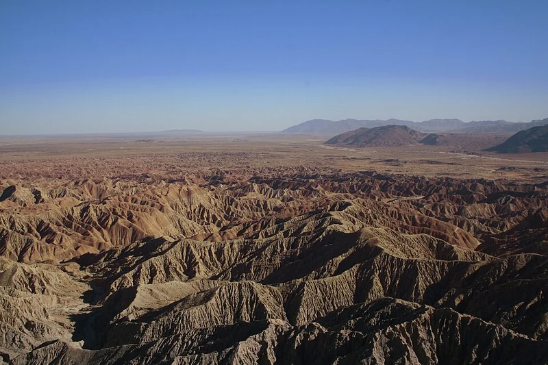
San Diego County · Borrego Springs
Anza-Borrego Desert State Park is the largest state park in California at 600,000 acres — larger than the state of Rhode Island. The park surrounds the town of Borrego Springs, which is a certified International Dark Sky Community with some of the clearest night skies in Southern California. Wildflower season typically peaks mid-February through mid-March after wet winters; outstanding blooms occur every 5–10 years and the park posts real-time bloom updates at theabf.org. The Borrego Badlands (Erosion Road, 18 miles of unpaved road) and Font's Point (4-mile round trip) provide badlands views requiring a high-clearance or 4WD vehicle. Coyote Canyon Road north of town is the primary wildflower corridor. The park has no entry fee; Borrego Springs has hotels, RV parks, and one grocery store.
Watch on YouTube · View on Google Maps
Crystal Cove State Park Must-see
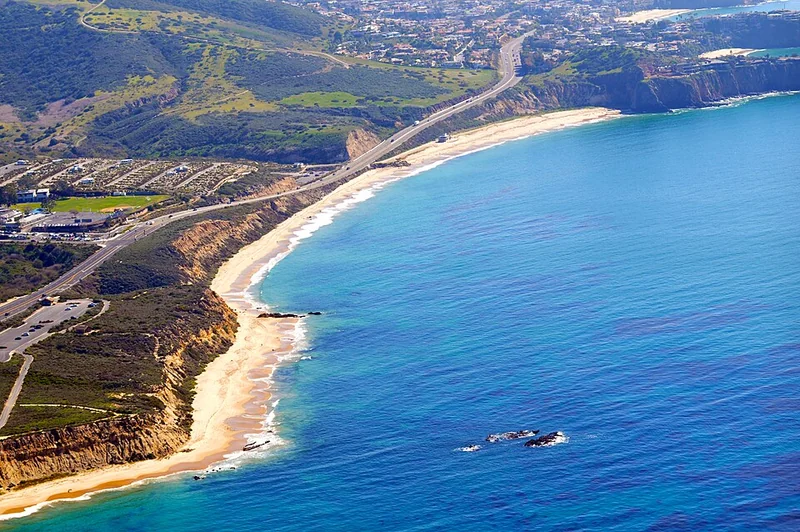
Orange County · Newport Beach
Crystal Cove State Park covers 3.2 miles of beach and 2,400 acres of inland wilderness in Orange County between Newport Beach and Laguna Beach. The underwater park (20 acres of protected tide pools) holds California's most diverse tide pool ecosystem in Southern California — access is from the beach stairs below Pacific Coast Highway. El Moro Canyon Trail (8.2 miles loop) climbs 1,000 feet through coastal sage scrub to a ridge with views of Catalina Island on clear days. The Crystal Cove Historic District — 46 vintage beach cottages from the 1930s–1940s — can be rented through the state park system (reservations open 6 months in advance). Parking fills by 9 a.m. on summer weekends; the Newport Beach transit bus stops at the park entrance on PCH.
Watch on YouTube · View on Google Maps
Mono Lake Tufa State Natural Reserve Must-see
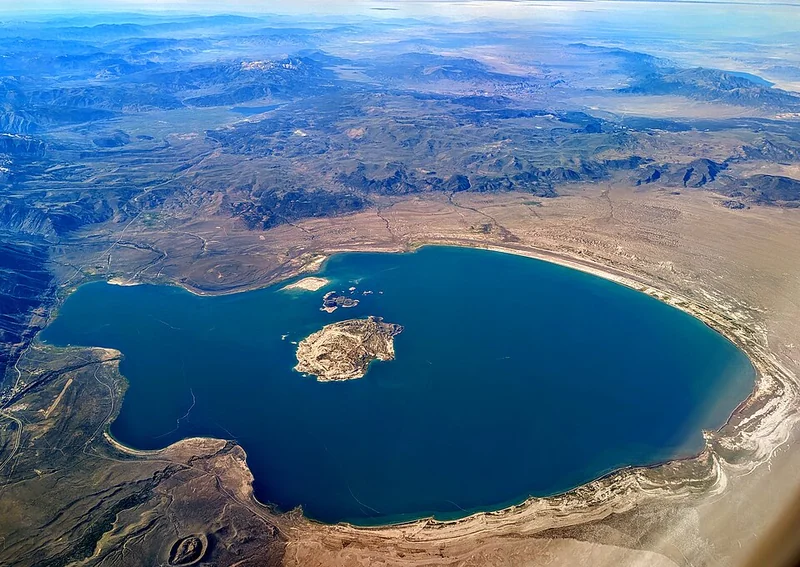
Mono County · Lee Vining
Mono Lake is a 70-square-mile salt lake east of the Sierra Nevada in Mono County — no outlet, so minerals accumulate over its 760,000-year history, making it 2.5 times saltier and 80 times more alkaline than the ocean. The tufa towers (calcium carbonate spires) formed underwater as freshwater springs met the alkaline lake — exposed when Los Angeles began diverting the lake's feeder streams in 1941, dropping the level by 47 feet. The South Tufa area (3-mile round trip) is the main viewing site with towers reaching 30 feet tall. The lake supports 85% of California's gull population during nesting season (April–August). Lee Vining on US-395 has lodging; the reserve is 5 miles east of town.
Watch on YouTube · View on Google Maps
Planning Notes
Plan your visit: Muir Woods and Point Reyes are 30–45 minutes from San Francisco — both fit into a day trip. See our San Francisco guide for where to base yourself. Redwood National Parks and Mount Shasta require a multi-day northern California circuit; the nearest cities are Redding (45 miles from Burney Falls) and Eureka (45 miles from Redwood). Channel Islands and Crystal Cove are within 2 hours of Los Angeles — see our Los Angeles guide for logistics.