New York's natural range is easy to underestimate from a map. The state extends 330 miles from Long Island's Atlantic barrier beaches to the Adirondack High Peaks — and between them sit Finger Lakes gorges, Catskill waterfalls, and a canyon in western New York that earns the name "Grand Canyon of the East" without exaggeration.
The spots below are drawn from a statewide travel dataset built on curated field research. They're organized by region so you can structure a trip without backtracking.
10 destinations selected from a curated US travel dataset — prioritized by regional distribution, visitor significance, and independent research. Must-see and Worth-the-detour ratings reflect relative value within New_york.
Jump to: Catskills & Hudson Valley · Finger Lakes · Western New York · North Country & Long Island · Planning Notes
Catskills & Hudson Valley
The Catskills and Hudson Highlands sit within 2 hours of New York City but feel genuinely remote. This region has the state's best waterfall hiking and its most accessible gorge trails.
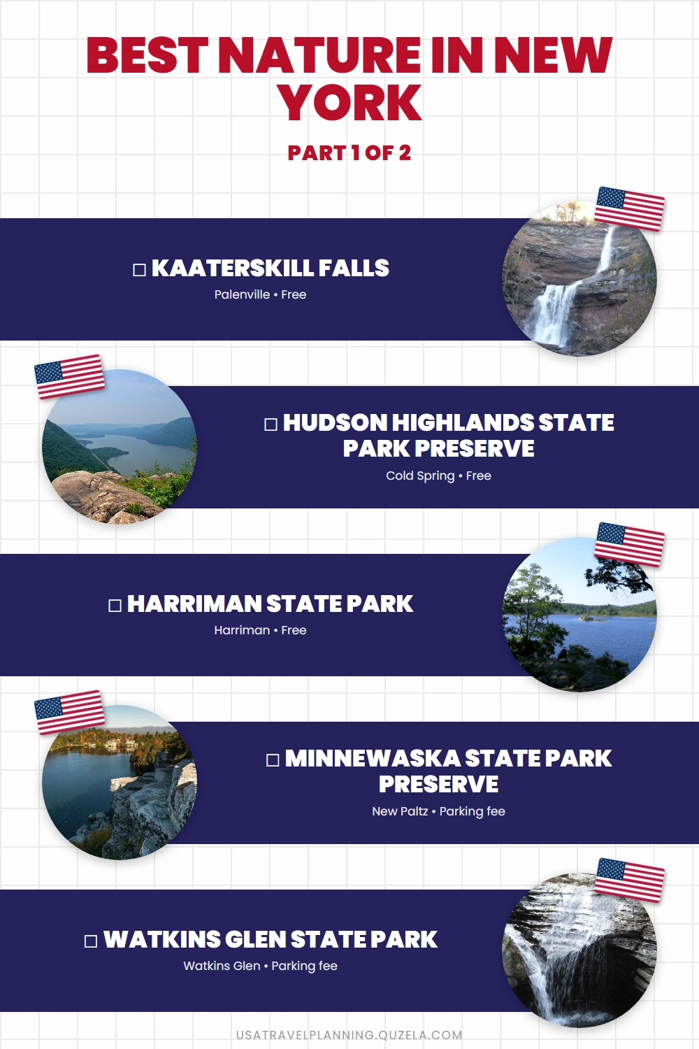
Kaaterskill Falls (Highest Waterfall in NY) Must-see
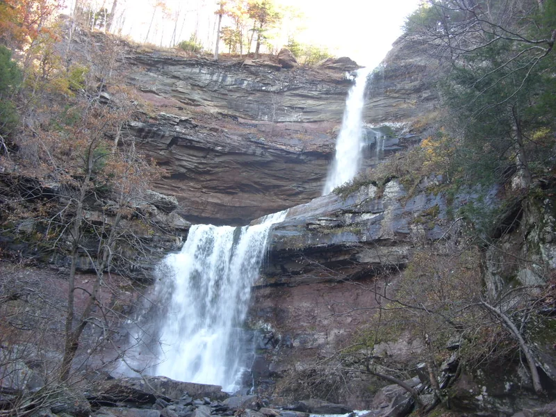
Greene County · Palenville
At 260 feet total — 175-foot upper tier and 85-foot lower tier — Kaaterskill is the tallest two-tier waterfall in the eastern United States. The trail to the upper falls is 1.3 miles round trip from the Route 23A pullout near Palenville, with steep rocky sections near the top. The 19th-century Hudson River School painters came here specifically — Thomas Cole painted the falls multiple times, and the surrounding forest looks largely unchanged from those canvases.
Arrive before 9am on weekends: the Route 23A roadside parking fills early in summer. The lower falls require a separate trailhead and are less visited.
Watch on YouTube · View on Google Maps
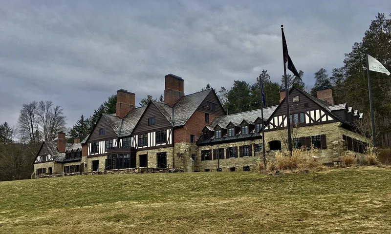
Hudson Highlands State Park Preserve Must-see
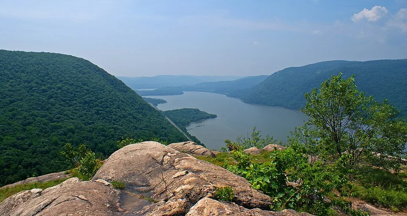
Putnam County · Cold Spring
Over 8,000 acres along the Hudson River's most dramatic stretch, where the river cuts through the ridgeline creating views down the valley in both directions. Bull Hill (Mount Taurus) reaches 1,420 feet with an open rocky summit — the climb from Cold Spring train station is 2.5 miles with 1,200 feet of gain. The trail system connects Breakneck Ridge (one of Metro-North's most-requested hiking stops) to Bull Hill via the Cornish Estate ruins.
Access via Metro-North's Hudson Line to Cold Spring station is practical — no car needed. The village of Cold Spring has restaurants and shops for post-hike stops.
Watch on YouTube · View on Google Maps
Harriman State Park Must-see
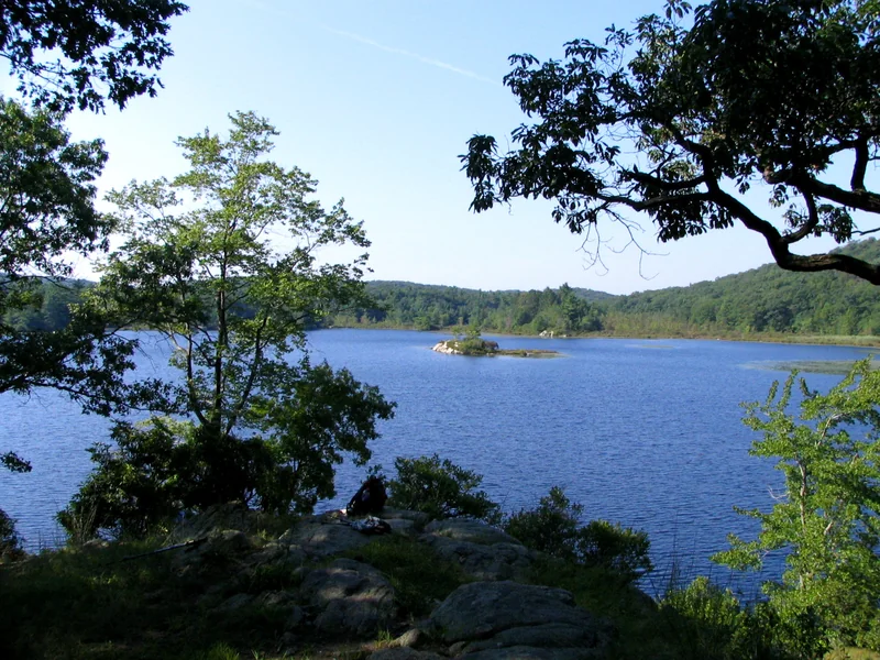
Rockland County · Harriman
47,000 acres and over 200 miles of marked hiking trails, 30 miles from Midtown Manhattan. Harriman has 30+ lakes and reservoirs, ridge-top views across the Hudson Valley, and enough trail mileage for multi-day backpacking within the park. The Appalachian Trail passes through on its way north.
The park is free and has no mandatory parking fees at most trailheads. Weekends in fall fill the nearest lots — arrive before 8am or take the Shortline bus from Port Authority.
Watch on YouTube · View on Google Maps
Minnewaska State Park Preserve (Shawangunk Ridge) Must-see
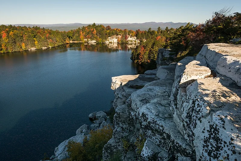
Ulster County · New Paltz
22,000 acres on the Shawangunk Ridge, the northeastern extension of the Blue Ridge Mountains. The signature feature is the sky lakes — Lake Minnewaska and Lake Awosting sit at over 1,650 feet elevation on white conglomerate bedrock, surrounded by pitch pine and blueberry with long views in every direction. The carriage roads are open year-round for hiking, cross-country skiing, and mountain biking.
The Gunks (as climbers call the Shawangunks) are also among the top rock climbing destinations in the Northeast — the cliffs below the ridge are a separate access point used by climbers.
Watch on YouTube · View on Google Maps
Finger Lakes
The Finger Lakes cut deep into the bedrock of central New York, creating gorge systems that concentrate more waterfalls per mile than anywhere else in the state.
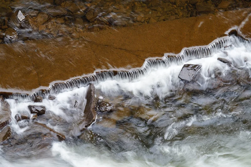
Watkins Glen State Park Must-see
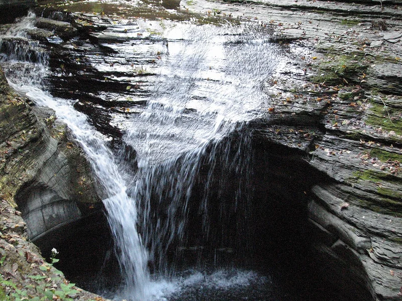
Schuyler County · Watkins Glen
The 2-mile Gorge Trail passes 19 waterfalls and crosses the stream 32 times on stone bridges through a tight canyon with walls rising 200 feet. Central Cascade Falls drops 60 feet directly onto the trail. The walkway was carved into the rock in the 1930s by the Civilian Conservation Corps — much of it goes through tunnels and beside walls that funnel water against the stone at close range.
The gorge is seasonal (typically mid-May through November). Get to the lower gorge entrance by 8am on summer weekends before parking fills. The park connects to Seneca Lake, the deepest of the Finger Lakes, for post-hike swimming.
Watch on YouTube · View on Google Maps
Taughannock Falls State Park Must-see
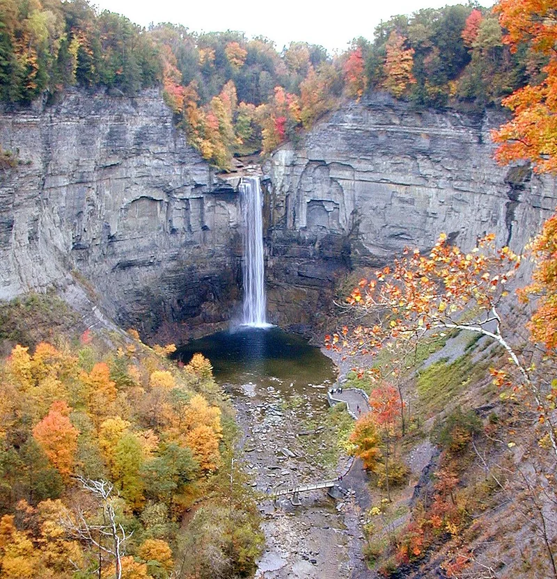
Tompkins County · Trumansburg
Taughannock Falls drops 215 feet in a single free-fall plunge — 48 feet taller than Niagara Falls. The gorge walls reach 400 feet on either side. The Gorge Trail runs 1.5 miles round trip on flat terrain from the lower parking lot, making this the most accessible major waterfall hike in the state — no significant elevation gain or scrambling required.
The park sits 10 miles north of Ithaca on the western shore of Cayuga Lake. A separate rim trail above the gorge offers top-down views from 400 feet up. Best visited in spring when snowmelt maximizes the falls' volume.
Watch on YouTube · View on Google Maps
USA Travel Planner — Google Sheets
One purchase. Every US state. Forever.
A pre-filled travel dashboard for every US state — we are actively building them out.
- 75+ curated attractions — pre-researched for you
- Built-in budget tracker (countdown, expenses, remaining)
- Step-by-step planning tabs
- Buy once — get all future states free as they launch
Western New York
Letchworth State Park (Grand Canyon of the East) Must-see
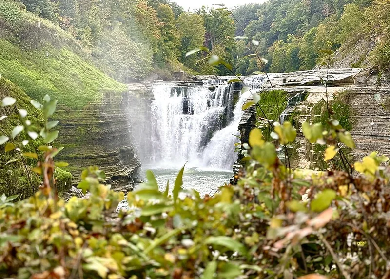
Wyoming County · Castile
The Genesee River has carved a gorge 600 feet deep and 17 miles long through western New York. Three major waterfalls drop within the gorge: Lower Falls (70 feet), Middle Falls (107 feet with a natural stone bridge), and Upper Falls (70 feet over a wide ledge). The park spans 14,350 acres with 66 miles of trails, a museum dedicated to the Seneca Nation, and hot air balloon operations running regularly in season.
October foliage at Letchworth rivals anything in New England — the gorge walls turn red and gold while the falls run hard after autumn rains. Summer weekends are crowded; arrive before 9am or visit midweek. The Inspiration Point overlook above Middle Falls is the park's most photographed spot.
Watch on YouTube · View on Google Maps
Allegany State Park Must-see
Cattaraugus County · Salamanca
New York's largest state park at 65,000 acres, bordering the Allegheny National Forest in Pennsylvania. The park has 100 miles of hiking trails through hardwood and hemlock forest, two lake areas (Red House and Quaker), and extensive cabin and camping infrastructure that stays booked through summer. Cross-country skiing on 20+ miles of groomed trails runs December through March.
Allegany sits in the far southwest corner of the state near Salamanca, within the Seneca Nation of Indians territory. The less-visited setting keeps crowds manageable even on summer weekends. Drive the Red House Lake loop road in early morning for wildlife sightings.
Watch on YouTube · View on Google Maps
North Country & Long Island
Ausable Chasm (Grand Canyon of the Adirondacks) Must-see
Clinton County · Ausable Chasm
The Ausable River has carved through 500-million-year-old Potsdam sandstone to create a gorge with walls up to 200 feet high. The chasm opened to visitors in 1870, making it one of the oldest tourist attractions in the country. The walking tour winds through the canyon on a series of bridges and staircases; rafting and tubing options take you through the lower section on the water.
Located 12 miles south of Plattsburgh near Lake Champlain, Ausable Chasm is a logical add-on to any Adirondacks itinerary. Admission covers the walking tour; raft tours are priced separately and should be booked in advance in summer.
Watch on YouTube · View on Google Maps
Fire Island National Seashore Must-see
Suffolk County · Fire Island
A 32-mile barrier island with no private cars — accessible only by ferry from Bay Shore, Sayville, or Patchogue on Long Island. The National Seashore covers the undeveloped sections between Fire Island's 17 communities. The Sunken Forest is the highlight: a 300-year-old maritime holly forest growing below the dune line, accessible via a 1.5-mile boardwalk that winds through gnarled canopy.
Ferry crossings run year-round but service is reduced in winter. The Fire Island Wilderness at the island's eastern tip has no facilities and is only reachable by private boat or a 7-mile hike from Watch Hill. Plan for a full day — the round-trip ferry plus walking time adds up quickly.
Watch on YouTube · View on Google Maps
Planning Notes
Best seasons: Spring (April–May) delivers the strongest waterfall flow after snowmelt — ideal for Taughannock, Kaaterskill, and Letchworth. Fall foliage peaks mid-October in western New York and the Catskills. Summer is busiest at all gorge parks; arriving before 9am avoids the worst of parking and trail crowding. Fire Island is best May through September.
Getting around: A car reaches all sites except Hudson Highlands (Metro-North to Cold Spring) and Fire Island (ferry from Long Island). Harriman is the only park accessible without a car from NYC via transit. Western New York parks (Letchworth, Allegany) require driving — both are roughly 6 hours from NYC.
Plan your visit: Watkins Glen State Park is part of a full Finger Lakes itinerary — see Watkins Glen for the complete guide including Finger Lakes Wine Country and the raceway.