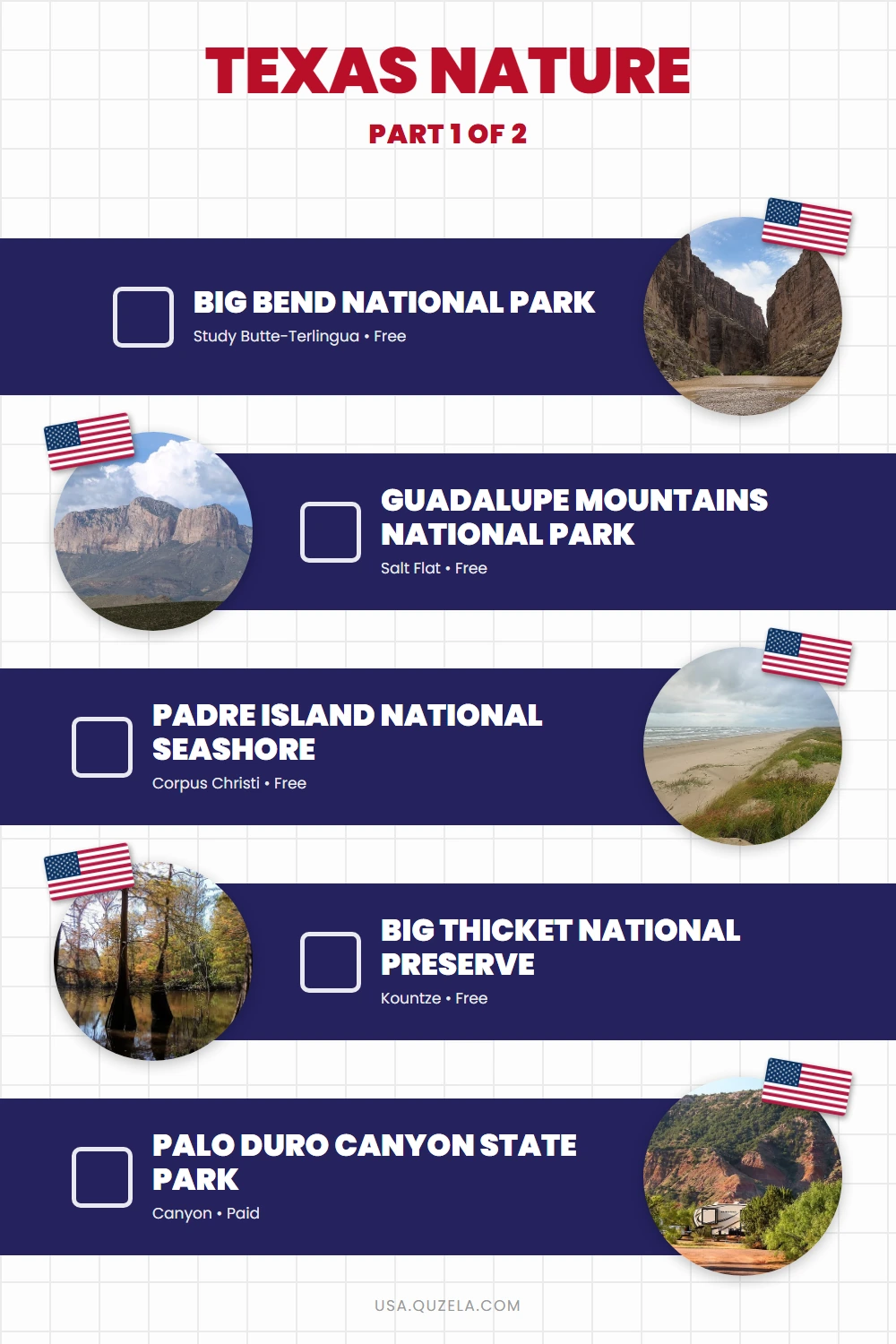
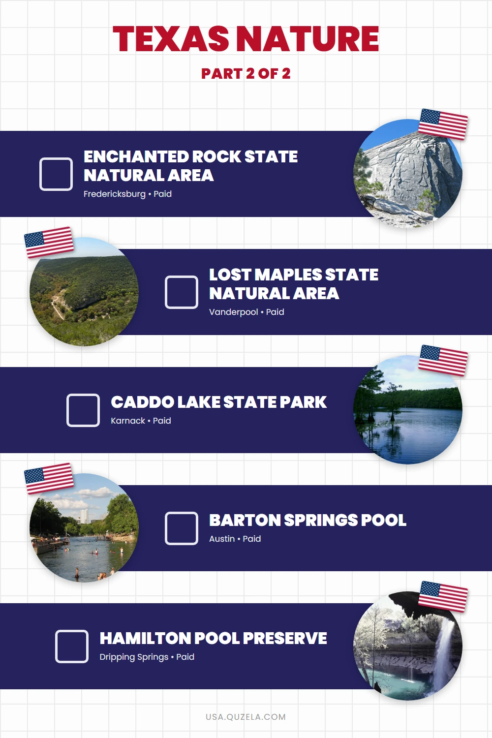
Texas spans five distinct ecological zones — Chihuahuan Desert, Gulf Coast barrier island, East Texas Piney Woods, Hill Country limestone karst, and Panhandle canyon country — each producing a completely different outdoor experience. Big Bend covers more land than Rhode Island. Enchanted Rock is a 640-million-year-old granite batholith. The Hill Country swimming holes hold 68°F in August through underground aquifer pressure. Pick the landscape that fits your trip, then book reservations 3–5 months ahead for any popular spring or fall weekend.
10 destinations selected from a curated US travel dataset — prioritized by regional distribution, visitor significance, and independent research. Must-see and Worth-the-detour ratings reflect relative value within Texas.
Jump to: National Parks & Preserves · State Parks & Natural Areas · Swimming Holes · Planning Notes
National Parks & Preserves
Big Bend National Park Must-see
Brewster County · Study Butte-Terlingua
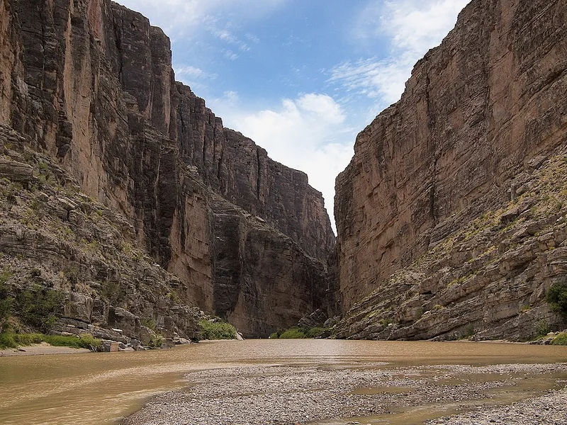
Big Bend covers 801,163 acres of Chihuahuan Desert along a 118-mile stretch of the Rio Grande — the most remote national park in the lower 48, with no cell service and no services for 80+ miles in any direction. The Chisos Mountains rise to 7,832 feet at Emory Peak, and the Santa Elena Canyon cuts a 1,500-foot slot through sheer limestone walls at river level. Over 150 miles of maintained trails include the 12.6-mile South Rim loop at 7,200 feet, the park's signature overnight hike. The nearest fuel and groceries are in Study Butte-Terlingua, 25 miles west of the main entrance — stock up before entering. Chisos Basin campground requires reservations via recreation.gov from September through May. The park holds a Gold Tier International Dark Sky designation, giving it the darkest skies accessible by road in Texas.
Watch on YouTube · View on Google Maps
Guadalupe Mountains National Park Must-see
Culberson County · Salt Flat
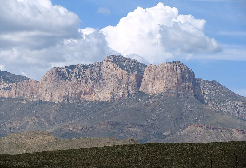
Guadalupe Peak at 8,749 feet is the highest point in Texas, and the 8.4-mile round-trip summit trail gains 3,000 feet from the Pine Springs Trailhead — plan 4–6 hours for the ascent and descent. The park charges no entry fee and has no food service or indoor lodging inside its boundaries. McKittrick Canyon, a 6.8-mile round trip through a shaded limestone canyon with bigtooth maples, peaks in October for fall color and is the park's second major hike. El Capitan — the sheer 2,000-foot limestone escarpment visible from US 62/180 — served as a navigation landmark for Butterfield Overland Mail coaches in the 1850s. The nearest accommodation is in White's City, New Mexico, 36 miles north. No reservations needed; Pine Springs and Dog Canyon campgrounds are walk-in.
Watch on YouTube · View on Google Maps
Padre Island National Seashore Must-see
Kleberg County · Corpus Christi
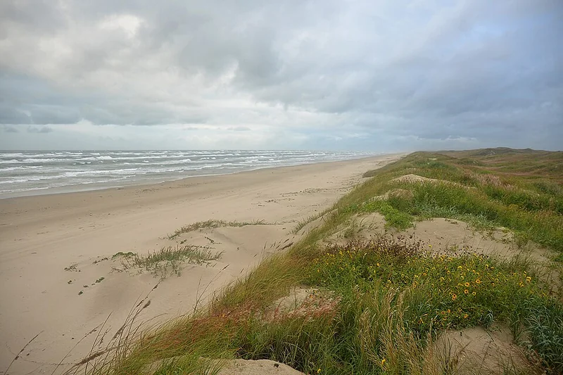
Padre Island National Seashore protects 70 miles of undeveloped Gulf Coast barrier island — the longest stretch of undeveloped barrier island in the world. The paved road ends at the North Beach area, 5 miles from the entrance; beyond that, only 4WD vehicles can continue on the hard-packed sand. From April through August, the park runs public Hatchling Release events when Kemp's ridley sea turtle nests emerge — the rarest sea turtle in the world, now recovering here after population collapse in the 1980s. The entrance is 10 miles south of Corpus Christi via Park Road 22. Beach camping at North Beach is first-come, no reservation needed. Bring everything — no stores or services inside the seashore.
Watch on YouTube · View on Google Maps
Big Thicket National Preserve Must-see
Hardin County · Kountze
Big Thicket National Preserve spans 113,000 acres of East Texas wetland, longleaf pine forest, and cypress swamp — a convergence of nine distinct ecological communities from eastern deciduous forest to western grassland to subtropical Gulf Coast, producing over 1,000 plant species and 350 bird species in a single preserve. Four of Texas's five carnivorous plant species grow here: pitcher plants, sundews, bladderworts, and butterworts. The Turkey Creek Trail in the Hardin County unit (8.7 miles) is the best single walk for seeing the ecosystem shift from upland pine to bottomland cypress. The preserve is not a single contiguous unit but 15 separate tracts across 7 counties — start at the Big Thicket Visitor Center on FM 420 near Kountze, 20 miles north of Beaumont. No entry fee; no reservations needed for day hiking.
Watch on YouTube · View on Google Maps
State Parks & Natural Areas
Texas State Parks open reservations exactly 5 months in advance. Enchanted Rock, Palo Duro Canyon, and Lost Maples fill within hours of the window opening for peak weekend dates — set a calendar reminder.
Palo Duro Canyon State Park Must-see
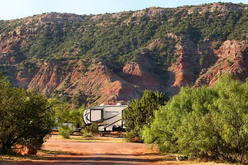
Randall County · Canyon
Palo Duro Canyon is the second-largest canyon in the United States — 120 miles long, up to 20 miles wide, and 800 feet deep — carved by the Prairie Dog Town Fork of the Red River through the Texas Panhandle. The state park covers 29,182 acres of the canyon's most dramatic section, accessed via a 5-mile paved road that descends to the canyon floor. The 5.5-mile Lighthouse Trail leads to the park's signature formation, a 310-foot sandstone hoodoo pillar. The outdoor musical drama Texas runs Thursday through Saturday, June through August, at a 1,400-seat amphitheater on the canyon floor — buy tickets ahead on the park website. Day-use admission is $8 per person. The entrance is 12 miles south of Canyon, TX, via TX-217.
Watch on YouTube · View on Google Maps
Enchanted Rock State Natural Area Must-see
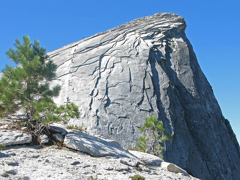
Llano County · Fredericksburg
Enchanted Rock is a 425-foot exposed granite dome — part of a batholith formed 640 million years ago — that rises from the Hill Country 17 miles north of Fredericksburg on FM 965. The Summit Trail is a 0.6-mile scramble on bare rock with 350 feet of elevation gain; there is no marked path on the dome, you climb the face directly. The full 4-mile loop via Echo Canyon and Freshman Mountain adds a narrow canyon passage and views of the surrounding Hill Country. Timed day-use passes are required from March through October and sell out weeks or months in advance at the Texas State Parks portal ($8 per person). On weekends, the parking lot fills by 9 a.m. and the park closes to new arrivals — arrive before 8 a.m. or book a camping spot to guarantee access.
Watch on YouTube · View on Google Maps
Lost Maples State Natural Area Must-see
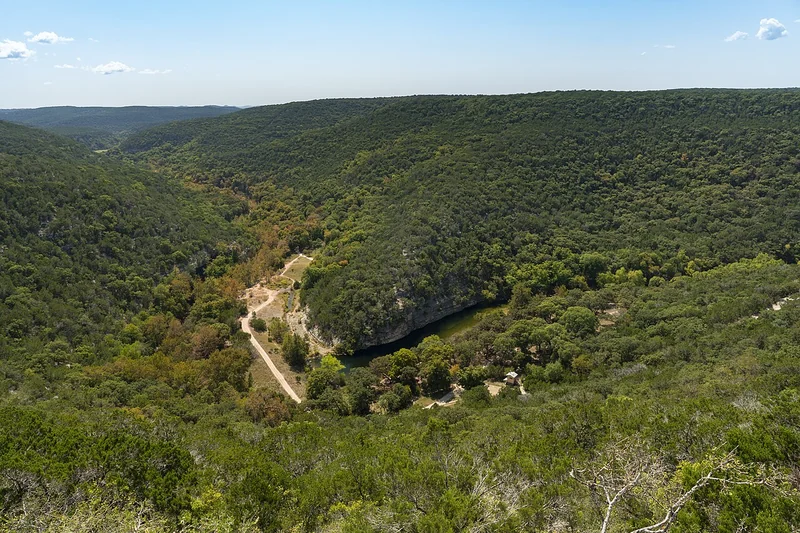
Bandera County · Vanderpool
Lost Maples protects an isolated stand of bigtooth maples in the limestone canyons of Bandera County — a relict population left over from a cooler, wetter climate that persisted through the last ice age. These maples turn copper, orange, and red in late October to early November, making this the definitive fall foliage destination in Texas. The 10.5-mile East Trail loops through Sabinal Canyon, descending 350 feet to the creek and passing Monkey Rock, a balanced limestone formation above the water. Day-use fee is $7 per person; timed entry is required on October and November weekends and sells out weeks ahead. The park is 50 miles northwest of San Antonio via TX-16 and RR-187 in Vanderpool, Bandera County. No cell service on-site.
Watch on YouTube · View on Google Maps
Caddo Lake State Park Must-see
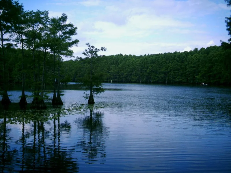
Harrison County · Karnack
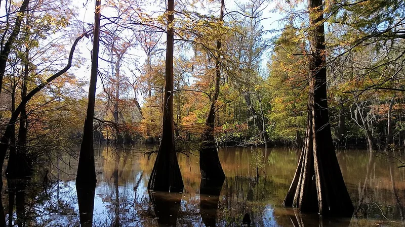
Caddo Lake is the only naturally formed lake in Texas, created by a massive log jam on the Red River that backed water across a 25,400-acre cypress swamp. The lake system is a Ramsar Wetland of International Importance, with over 70 fish species and one of the highest freshwater turtle densities in North America. Canoe and kayak rentals are available at the park from March through October ($20/hour); paddling the maze of cypress bayous beneath a canopy of Spanish moss is the main draw. The 1.2-mile Saw Mill Trail loops through bottomland forest at the edge of the lake. The state park covers 484 acres near Karnack in Harrison County, 15 miles northwest of Marshall via TX-43. Cabins and screened shelters can be reserved 5 months ahead.
Watch on YouTube · View on Google Maps
USA Travel Planner — Google Sheets
One purchase. Every US state. Forever.
A pre-filled travel dashboard for every US state — we are actively building them out.
- 75+ curated attractions — pre-researched for you
- Built-in budget tracker (countdown, expenses, remaining)
- Step-by-step planning tabs
- Buy once — get all future states free as they launch
Swimming Holes
The Edwards Plateau limestone beneath the Hill Country feeds spring-fed pools that hold 68°F regardless of air temperature. The same underground aquifer that supplies Austin's drinking water keeps Barton Springs cold in August.
Barton Springs Pool Must-see
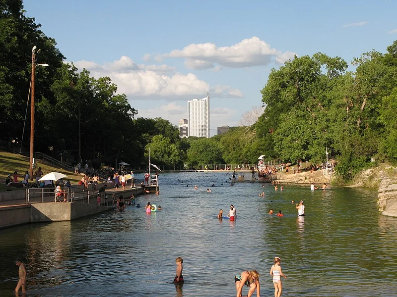
Travis County · Austin
Barton Springs Pool is a 3-acre spring-fed swimming pool in Zilker Park that holds 68°F year-round, fed by underground springs at 27 million gallons per day. The pool is 900 feet long with a maximum depth of 9 feet, a sandy gravel bottom, and a grassy lawn along both banks for sunbathing. Admission is $9 per person on weekends and $5 on weekdays; entry before 8 a.m. is free daily. The endangered Barton Springs salamander — found nowhere else on Earth — lives in the spring outflows. The pool closes Tuesday and Thursday mornings for cleaning. Zilker Park is 2 miles southwest of downtown Austin at 2201 Barton Springs Rd; parking costs $5 on weekends, or walk from the Congress Avenue bridge (1.2 miles).
Watch on YouTube · View on Google Maps
Hamilton Pool Preserve Must-see
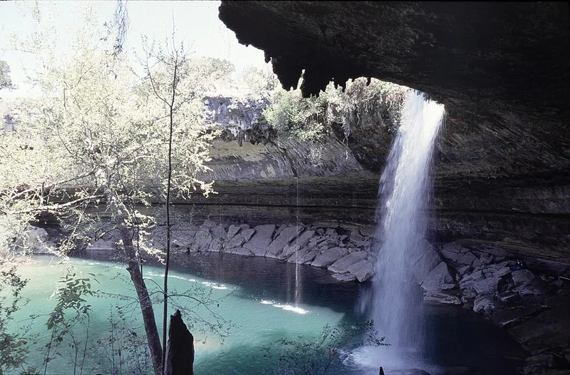
Travis County · Dripping Springs
Hamilton Pool Preserve is a collapsed grotto where Hamilton Creek drops 50 feet over a curved limestone overhang draped in maidenhair fern into a jade-green pool below. The water averages 60–68°F. Swimming is subject to daily E. coli testing — Travis County Parks posts water quality results by 9 a.m. on the preserve's website before you drive out. Advance reservations are required every day of the year ($10/vehicle + $15/person) and the 24-vehicle daily capacity sells out weeks ahead from March through October. The 0.5-mile trail from the parking area descends 100 feet to the grotto. The preserve is 23 miles west of Austin via TX-71 and Hamilton Pool Road. Morning visits get the best light — the overhang shades the pool by midday.
Watch on YouTube · View on Google Maps
Planning Notes
Plan your visit: Several parks in this article are near Texas city guides with lodging and dining options: Austin (Barton Springs Pool), Fredericksburg (Enchanted Rock), Canyon (Palo Duro Canyon), and Corpus Christi (Padre Island National Seashore). Use those guides to plan your base for each park.